molash

As stated, the most important building in Molash is the Church but there are other aspects of the village and its surrounding area which also hold interest; for example: King's Wood. There are several houses which date from the 16th century or earlier.

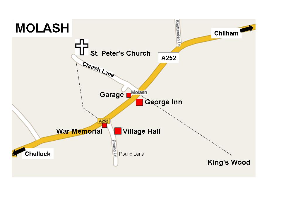
But first, where is Molash?

This map shows you the (few) main buildings in Molash and two footpaths; one, by the side of the George Inn, leading to King's Wood.

Molash

This map shows you where Molash is - by clicking on these maps you can zoom in and out to place it within Kent, England and the British Isles.


uk

map

Google maps is also useful and gives a good satellite view of Molash.

View Larger Map

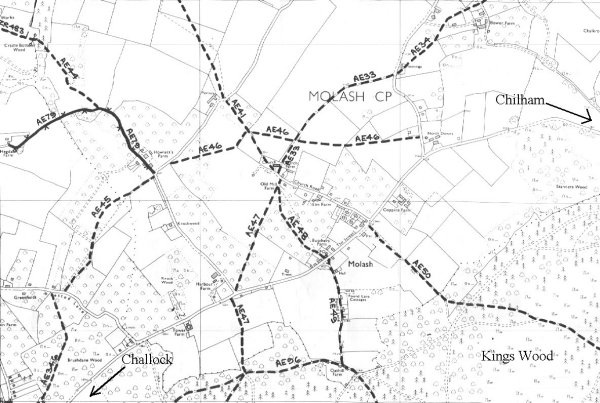
This map shows the public footpaths around Molash:

Footpaths

Here is a relatively easy short walk (not suitable for wheelchairs and prams) before a pint at the George Inn: park at the George and walk a few paces north (left of the George as you face it and opposite the garage); you will see a gap in the hedge off the main road, turn right, this is the beginning of the AE50 footpath, and walk along the edge of the field at the left side of the George. At the corner of the George you should see a path straight across the field with the forest in sight. Head across this field, go through the following hedge (there used to be a style here) and walk across the next field to the forest. Both these fields are walked fairly regularly so the paths should be clear to follow. When wet they are very muddy.

You are now in King's Wood. Head down the path in front of you. It is quite steep and looks like the path of a small stream. At the end of this steep path turn right and walk about 30m to a woodland crossroads, turn right (small pond on your right) and walk along the "road" for about 600m until you see a large gate to your right, go through the side pedestrian gate, past a horse training paddock on your left, walk to the corner and turn right up the hill on a partly paved lane This is the AE49 footpath. At the top is Pound Lane proper with houses on your right, walk to the main road (A252) passing the village hall (right) and then the War Memorial (left). Cross the road to the footpath and turn right and it is a short walk back to the George Inn. Be careful crossing the road here. This walk should take no longer than 30-40 minutes.

This map shows the parishes in Ashford Borough - Molash is at the top:

parishes

King's Wood

King's Wood is a short walk from Molash using a footpath immediately to the north side of the George Inn or, south, down Pound Lane off the A252.

King's Wood is owned by the Forestry Commission.
Click here

The following text is copied from the Kentish Stour Countryside Project web site

Parking, main access on White Hill: from Challock village take the A251 towards Ashford. Turn left onto White Hill, signposted Wye. GR 024500

With such a regal name, it should come as no surprise that King's Wood was historically a royal hunting forest. The quarry pursued by the great and the good here were deer, and a large herd of fallow deer still run free in the wood. These days, King's Wood is largely owned and managed by the Forestry Commission. In addition to large stands of fast-growing conifers, there is extensive sweet chestnut coppice. Although timber production is important, management of the woodland is increasingly geared towards conservation as well. The bird life is rich, and this is also a good place to see fungi.

This large, attractive woodland is also an important recreation facility for the public. Visitors can walk right through the site, enjoying views across wooded valleys and the feeling of being in the middle of a really big forest. Walks are made easier by a way marked trail starting at the car park. As well as enjoying the landscape and wildlife of the woodland along this route, visitors can see sculptures created by a variety of artists as part of the Stour Valley Arts Project. This is the Project's main site, with nine artists' work to see (at the time of writing) (see below). They range from Andy Frost's play sculptures and picnic furniture, a guaranteed hit with children, to the ingenious 'Coppice Cloud Chamber' by Chris Dury. The latest feature of the wood is an avenue of 180 yew trees, planted in the year 2000 to be in alignment with the sunset on the summer solstice.
For a map of all the sculptures in King's Wood click here.

For information on the sculpture trail and educational visits: Stour Valley Arts 01227 458759.

For leaflets and general information: Forest Enterprise 01580 211044 or contact KSCP.

Here are some pictures taken in Kings Wood in December 2002:

The Coppice Cloud Chamber by Chris Dury, built 1998, King's Wood, part of the h Stour Valley Arts Project.  
This sturdy igloo-like structure is, in fact, a camera obscura made from thousands of pieces of coppiced chestnut. Its solid appearance belies the magical quality of the delicate reflected image it contains, of the sky and the treetops above. As you step from the Cloud Chamber, the surrounding landscape seems more luminous, more clearly defined.

This chamber is 6m wide and 5m high, made of over three thousand stacked coppiced chestnut logs built into a steep bank over an old flint pit. There is a small Z-shaped passageway in and a lens in the roof which projects treetops and sky on to a circular disc on the floor. The work is situated about halfway from the car park to the left of steps up a wooded bank, on the way marked three mile trail.
OS Landranger Map 189, Ashford & Romney Marsh. 03.3 longitude, 51.1 latitude.  


Sculptor Giuliano Mauri, from Lodi, Italy, was in residence in King's Wood for three weeks in summer 1999 when he made three enormous basket-like structures for the Stour Valley Art Project; these no longer exist:

The Pilgrim's Way footpath to Canterbury runs through King's Wood along the ridge of the North Downs.

More pictures to follow.


leafHome     leafCalendar